
Avid blog followers will know
that in August 2016 we undertook the West side of the C2C across the Lake
District. With sufficient elapsed time to forget the hard work involved we
decided to start this years trip by undertaking the Eastern “half”.
Returning to Kirkby Stephen
we stayed at a wonderful new B&B at Redmayne House. Having noticed an
unusually strong country odour our hosts advised that just up the road were the
evening sheep sales.

The yards have been around
for many many years and it was obviously an activity with a small fraternity
who seemed to enjoy the whole spectacle with some quite amusing moments. The
lady to the left of the auctioneer was madly recording what was a quite
frenetic process with sheep entering on one side just as others were leaving.
She had the job of keeping an electronic record which is shown on a large
screen above her head – the only sign of modern technology.

A very serious business on
some occasions – the top price has been 120,000 GBP for one ram…..

The next day we set off walking in glorious
weather across a bridge over the river Eden.

As I did in 2016, the photos have been grouped into themes rather than a chronology. So for those keen to follow our route the
schedule was:
Day 1 – 21 kms Kirkby Stephen
to Keld
Day 2 - 17.5 kms Keld to
Reeth
Day 3 – 17.5 kms Reeth to
Richmond
Day 4 – 22.5 kms Richmond to
Danby Wiske
Day 5 – 14.5 kms Danby Wiske
to Ingleby Cross
Day 6 – 20 kms Ingleby Cross
to Clay Bank Top
Day 7 – 15 kms Clay Bank Top
to Blakey Ridge
Day 8 – 14.5 kms Blakey Ridge
to Glaisdale
Day 9 – 13 kms Glaisdale to
Littlebeck
Day 10 17.5 kms Littlebeck to
Robin Hood’s Bay
Along the whole walk there
were many animals of which sheep took prominence. As our knowledge of sheep varieties is limited Helen thought (given their legs) these could be aptly
labelled Twiglets. (They are in fact Dalesbread.)

They are very comfortable
with walkers being nearby.

Many of the paths were Bridleways.

There was also quite a bit of
bird life of which pheasants were numerous

and Grouse were everywhere….

They do blend in well and

were fattening up for the
start of the annual shoot – here Blakey and his mates would be able to shoot at
will camouflaged in a line of Grouse Butts (This year the season started on the
13 August.)

We passed a Grouse farm which
was fenced to prevent animals entering but with bespoke gates that allowed the
birds to come and go at will. The fence did help with herding this deer so we
could get a few (photo) shots.

However, the animal shot of
the trip was this one on the last day. I noticed this animal initially walking
towards me and then we both froze. As I clicked the shutter to get a great head
on shot it lept 90 degrees and miraculously I got it in full flight. Any guesses?
– it is a Weasel – the first I have seen in the wild.

Along the way there was some
history – as this toll road was “unpersonned” it was particularly cheap.

And outright quirky – this
farm had a few seats, a fridge with goodies and an honesty box so it was
important to gain walkers attention as they went over the style.

The area is renowned for cycling and has its own Le Tour de Yorkshire as well as periodically being included in the Milk Race. As a result there are quite a few who pay homage with “sculptures” along the way.

Up the hill out of Littlebeck
was “The Hermitage” which was carved out back in 1790 – a large sheltered space
but its real purpose is unclear.

Of equally unclear purpose is
the Nine Standards Rigg out of Kirkby Stephen which dates back to at least
1507. What is clear is that this is the highest point on our path East of the
Lake District and lies on the watershed of Britain with rain on the left
travelling to the Irish Sea and that on the right flowing to the North Sea.

We deviated off the course
and across this pedestrian bridge so as to access Muker for a coffee.
Elaborate double span only suitable for pedestrians.

Whereas this bridge near Glaisdale (the Beggars bridge)

was specially tapered out at
the top to enable horses with Panniers to pass without grazing the sides.

What was in abundance were “cowouses”
(no “h”) which were used to winter cattle. Given the infrequency of cows I suspect
they are no longer in much demand.

By comparison Richmond castle has adapted from fending off attackers
to welcoming tourists.

The river Swale was our guide
for 4 or so days and in the flatter areas after Richmond was prone to
flooding. To keep out of the fields the path migrated to the top of the flood
wall. Quite a bit of concentration required given the 100+ metres length and 3
metre drop each side…..

Our arrival in Grosmount was
heralded by a cuppa in the station tea rooms while we awaited the main attraction.
We stopped here when we travelled by train with Michael et al last year (see
York & Vikings July 2018)

This structure had me
perplexed until Helen found a sign. It is near Robin Hoods Bay and is a rocket (rescue)
pole. A line was shot by rocket to ships grounded in the bay and then a
continuous line set up between the pole and a ships mast. A life belt with a pair
of shorts (breeches buoy) was attached and the unfortunate crewmen were then
hauled safely to shore. This one was used to rescue crew from the Heatherfield
in January 1936.

Rights of way (the path) were
generally well maintained although the purpose of this near new gate was a bit
of a mystery. (At least everyone obeyed the sign and kept the gate closed.)

Some gardens along the way were worthy of note – the war memorial
gardens in Richmond.

And our B&B near Clay Bank
Top were highlights.

The scenery was diverse but gorgeous. From woodland walks
near the river

To waterfalls
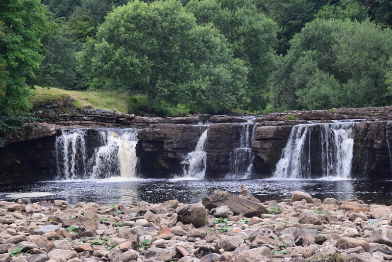
And waterfalls

And waterfalls

To some still water

And woodlands with wonderfully
dappled light

However, the best views were
at the top of the many climbs – this on the way down to Keld

And this the next day down to
Muker

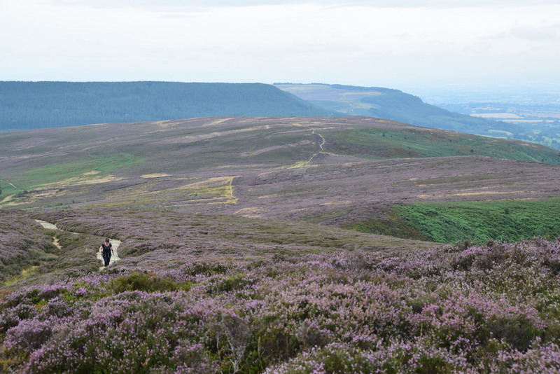
Clay Bank Top on the Yorkshire Moors has a great view of
where we had trekked

over three substantial escarpments – one of our bigger days.

Southwards the view was just
a mass of heather.
And finally the view we had
been looking forward to for much of the walk – the North Sea.

We met quite a few fellow
trekkers and an American couple were good enough to take this shot so as to
confirm I was there! One local walker tickled Helen's fancy when he "doffed" his cap at her. The talking point for much of the day!

For several days we kept
bumping into a German couple (Beate Lendt and Martin Klett who live in Holland).
Being a little younger than us they usually started later in the day, caught us up
at lunch time and were then waiting for us at the local pub for dinner. (Where were you - we have been worried sick??!!) It was
quite eerie how this cycle kept repeating.

The last (very memorable)
view was, as we rounded the headland, of Robin Hoods Bay. A welcome sight.

Thankfully the tide was in - low tide would have added a further 1 km
to the trip! We promptly went to the waters edge and dipped our boots.

And tossed the long carried
pebble from St Bees.

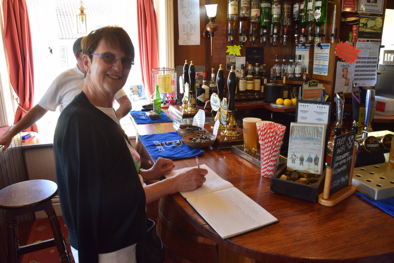
The Bay Hotel on the front

keeps a record of those who
have completed the journey and provides a certificate (for a nominal fee!)
After a wonderful evening at
the B&B we almost looked refreshed (or maybe that is relieved). (Zoom in on the tops.)

So there you have it – the C2C
in 2 years! I suspect many of you will think we are nuts. However, although there
is no doubt some of the walking was hard work the sense of achievement that we
have walked across England will live with us forever. Along the way we have enjoyed
some of the best countryside that England has to offer.

Thank you Wainright.....
No comments:
Post a Comment