Wednesday, August 31, 2016

Kent and some Déjà vu

We decided to spend the two or so weeks we had available for travel in the ‘van in SE England. Near to our site in Maidstone was Leeds Castle which claims to be the prettiest in England. Quite a claim but it is very picturesque with its moat and streams. The first structure dates back to a Saxon Manor as recorded in the Doomsday book of 1086.
The bridge to the castle is part of the Barbican which was built to protect the water supply to the moat and watermill. 
 
The moat is wide and would have been difficult to cross in an attack, however the castle was never rarely used as a defence and was only besieged twice when the resident offended the King (1139 and 1321).
 
One of the outbuildings was set in a beautifully tranquil garden.
 
The castle entrance grabbed our attention but unfortunately the barrels were all empty!
 
As we walked around they were sealing off various rooms in preparation for a wedding – a pretty expensive affair I suspect.

The last owner of the house Lady Baillie (1974) used the premises as one of her three homes. Her dressing case was made from silk, crocodile skin, gold and a new plastic (Bakelite?). I am told I should appreciate how light Helen travels. The castle is now part of a Trust set up by Lady Baillie.
 
Some of the fittings seemed be a little less practical than others. I suspect this may be an umbrella stand rather than a waste paper basket.
 
Nearby to the caravan park was Bearsted Woodlands. This was a lovely walking area developed by the local community with numerous young trees dedicated to various family members. One 300 year old oak tree (in the background) had fallen but rather than being removed was used as a climbing frame and for various owl carvings.
 
As well as a rabbit and a badger.
 
Sue and Martin were berthed in London and came by train to stay for a couple of days and explore this neck of the woods. Canterbury a mere 20 minutes away was our first port of call. We had all visited the cathedral in the past when entry was free it is now £15 so a second visit did not seem to represent value. The tower looks better from afar in any case.
We did a circuit of the streets around the cathedral where there were many historic sites. This pub built in 1503 was frequented by Charles Dickens.
 
As was this one which had a distinct lean. This appears to have stabilised since Charles D time when, in 1849, he wrote “… a very old house bulging out over the road … leaning forward, trying to see who was passing on the narrow pavement below….”
 
The river Stour passes through the city where you can be rowed or punted along quite a fast flowing course. Or you can continue discussions alongside the face sculpture outside the Marlow theatre.
 
The Roman wall around Canterbury was built in AD 270 – 290. Near the Eastern Queningate were statues of Ethelbert King of Kent and Bertha his Queen (597 AD). They stand outside St Augustine's which is part of the Kings School Canterbury.
 
There are many listed heritage buildings in Kent. We went to Sissinghurst where were greeted by Oast houses, drying hay (without a combine harvester) and a tower.
 
The tower enabled remarkable view over the gardens which were formally laid out but informally planted.

At the bottom of the garden was a reflective moat with a wall separating the orchard from immaculate lawns. The timing of Martin’s entrance was also immaculate arriving just as the crowds had dispersed.
We also visited Ightham Mote, a 14th Century moated manor house. Although wonderfully attractive on a bright sunny day, it is in a valley and was recovering from a flash flood in June. A number of rooms were out of bounds with fans working 24 hours to circulate air and help the drying process.  
 
Some of the rooms had quirky ideas. This alcove was square on one side and raked on the other.
 
Upstream the gardens included a calming lake
 
and the most twisted tree I have ever seen.
 
As many of you know Kent is an old haunt where I spent most of my teenage years, so it was appropriate to have a small trip down memory lane. I suspect this will appeal to only a small number of readers – so feel free to skip this bit…

Helen and I started our married life in a brand new old persons flat in Chatham. It is the top floor shown here. We furnished it with a bean bag (we cooked the beans in a pan), a table I built and a water bed on the floor as we could not afford a base. The flat does not look to have been maintained since it was constructed in ’73! I do recall emptying the water bed using a hose which was taken through the window and I held in the street. I did get told off by one passer by for peeing in the street. I am not sure mentioning water beds did anything to help his comprehension.
 
When I was 10 our family lived in a little village called St Nicholas-at-Wade which used to overlook fields all the way to the sea some 7 miles away. The fields are now used for agisting horses. I do recall being snowed in here in ’63 (when the sea froze), but the weather for our visit was perfect.
As I got in with a questionable crowd  we moved to a more pleasant town called Birchington right on the coast. The house was called Aston. Not much has changed here in 50 years.
 
There is still the walk down to the “beach” which used to be a bit of a ramp however, there is now a large promenade and sea wall in both directions.
 
We would have had a walk but as there was not a loo within sight we moved on……
 

I have to say that Sue and Martin were very tolerant of this part of the day and at some stages even feigned enthusiasm…
 
As we headed to Margate we had to snap this house which a best man in the USA will recognise and is where I parked my bike while working as a caddy on the adjacent Westgate golf course. The start of an addiction.
 
Margate was always a bit of a dive and somewhere locals travelled through rather than stopping. However, it is now looking quite attractive and on the left of this view is the new “Turner Contemporary” gallery. Quite an interesting construction into the sea.
 
As we continued around the coast we called into Broadstairs. The constant breeze has not just worn out the flag but also impacted this boat shed.
 
A little further on was Ramsgate and my high school Chatham House unfortunately hidden by scaffolding.

A real shock to my system is that the school has now been combined with Clarendon House (which is where sister Leslie went) and the two are now led by a female Head Teacher. What is the world coming to?

Saturday, August 20, 2016

C2C (or for those not in the know the Coast to Coast)

Helen is quite keen on walking (2 or 3 times a week stuff) and also loves the Lake District so it was a natural progression to consider walks in the Lake district and what better than the challenge of walking across England. The C2C goes from St Bees in the West (Irish sea) to Robin Hood Bay in the East (North sea). Although some have done this as part of a race in 54 hours we opted for a more leisurely pace. We also decided to do half this year (to Kirkby Stephen) and save the second half for a subsequent year. Eight days seemed appropriate.

The walk is one that was detailed by Alfred Wainright starting in 1952 in a wonderful little handbook.
We used a firm (Contours who booked the accommodation and ferried our cases between B&Bs). Our first B&B (Abbey Farm House) were prepared to park our car in return for a donation to their chosen charity.
We set off via the church and it’s 1160 Great West Door to a statue of St Bega. This daughter of an Irish King (600 AD approx) fled in a small coracle type boat when she refused to marry the man her father had chosen. When she landed she wanted to found a nunnery and approached Lord Egromont who laughingly promised her as much land as the snow covered the next day. The next day was midsummer and it snowed.
It is not even certain that St Bega even existed but snow on midsummer day is quite plausible!

Wainright wrote that you should transport a pebble to the East coast as well as dip your toe in the sea, so…

We even managed to cajole a passer by into taking a picture so you can see that I participated (well was at least at the start).


A dry but windy day with quite an upward hike to the lighthouse. The wind and sea spray prevented a viewing of the Isle of Man which is possible on a clear calm day.


As for the hike up it seemed significant at the time but would soon pale into insignificance!

Towards the end of our first day this milestone reminded us of how little we had travelled (albeit we had travelled a longer and more circuitous route than the sign suggests).

Rather than give a daily blow by blow account I thought grouping some highlights together would be more interesting. However, those with a map or a desire to link the blog with our schedule here is a summary:
Day 1 13.5 Kms St Bees tot Cleator Moor
Day 2 9 Kms Cleator Moor to Ennerdale Bridge
Day 3 23 Kms Ennerdale Bridge to Rosthwaite (B&B at Stonethwaite)
Day 4 14.5 Kms Rosthwaite to Grasmere
Day 5 13.5Kms Grasmere to Patterdale
Day 6 19 Kms Patterdale to Bampton
Day 7 18 Kms Bampton to Orton
Day 8 19 Kms Ortone to Kirkby Stephen

Days 3 to 6 included some substantial ascending and descending.

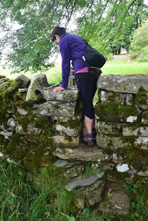
Most days we encountered stiles and streams. The stone stiles were robust affairs and tricky for the unwary as once your boot was in there was no turning back (around).


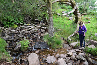
Boots are the best footwear so you can just march through streams, however if you opt for walking shoes you have to pick your way carefully across stones.

Deeper streams required a pause and route planning phase.

Mind you some of the paths required constant planning of which stone to step on. The 3kms around Lake Ennerdale was particularly slow (and at the end of the day painful).

There were some idyllic sections with paths of small gravel – not that this made travel any quicker given the various plants and other life that was in need of being photographed.

Animals were a constant photographic opportunity. These small calves were tentatively curious.

As they grew so did their friskiness..

When fully formed and lying across the track walking together was mandatory. Who gave way; well the cows of course.

Some were happiest with this size of animal.

However, the dominant species was sheep – from the curious

To the commanding – what are you doing on my patch?

Meanwhile this rock is just heavenly (reminded me of Baloo - man this is really living)

To some that were in the pink

And then of course there is the well known “white sheep of the family”.

Wherever we went we came across larks who in some instances took off when we were less than a foot away – quite startling. These two however seemed to have a need for a bit of fame (not that this blog can promise that).

We also encountered quite a bit of industry from various periods. There were several stone circles but the one near Orton was the most obvious. These are from the Neolithic period (around 2500 BC). Some have disappeared and all have been disrupted during ploughing over the years but they are still something to contemplate.

Moving forward a few thousand years was Shap Abbey founded in 1200 by some Premonstratensian canons. King Henry VIII suppressed the abbey and evicted the canons back in 1540. Although some plundering occurred it is now going through a significant conservation programme to stop further deterioration.

The corner foundations comprised a large area of stones to spread the load and resist outward pressure.

We also encountered a few lime kilns where limestone was fired to produce lime for construction. These were largely built in the 1800s but the technology goes back to Roman times.

More recently is the logging industry. However, it is going through a difficult period as many Larch trees (the only deciduous conifer native to Europe) now have a fungus and have to be felled so as to reduce the extent of the disease (sounds familiar with Dutch Elm disease and the removal of thousands of French plane trees – canal du midi). We saw thousands of logs stacked along the track in the forest beyond Lake Ennerdale.

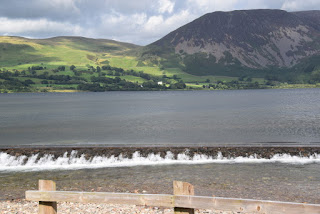
Lake Ennerdale was the start of day 3 and the first of fours days with a significant climb. A small weir is used to funnel water into a water treatment plant which other than for a couple of pipes was completely hidden away. We were looking forward to a quick 3 Kms walk on the flat along the length of the lake. Were we wrong; it was extremely stony and hard walking. Not the sort of start we wanted to a 23 kms climbing day!

The most modern structure was on day 7 when we crossed the M6 near Shap. What a racket.

However, the small footbridge over did give rise to a great and seemingly peaceful view (if you cut out the cement works!)

However, the last structure is perhaps the most commanding – this is the Smardale Gill (now unused) Carlisle to Settle railway viaduct. Built in 1861 by Sir Thomas Bouch it is 90 ft high and has fourteen arches. It closed in 1962 when steel making ceased. It seems to fit into the landscape.

The last two days were through rolling and well signposted countryside.

Mind you the popularity of the route has inevitably started to give rise to advertising signs – this one says “Bents Farm – Camping Barn”.

It would remiss not to spend sometime on the high point of the walk. On day 6 we were greeted immediately by a quite steep climb up to Angle Tarn. The weather was sunny and clear up to this point and then we started to enter the misty low cloud.

Although we were some way up there was still quite a bit more to go up to The Knott.


We eventually made it to the top (after a small diversion off the wrong track – easily done with poor visibility and tracks everywhere in the boggy conditions). Can we find our way? Of course we Cairn… which marked Kidsty Pike which at 780 metres was the highest point of the walk.


What was spectacular was dropping down out of the mist to sunny valleys below.

At the bottom we had to walk the 3 kms around Hawswater reservoir which supplies Manchester.

We had a brief stop for a snack and comfort stop (which as a Londoner only seemed appropriate).

There were waterfalls over many of the four climbing days. This one was on the way up from Rosthwaite (Day 4) – perfect weather.

Beautiful waterfall near Hause Gap on the way up from Grasmere.

Ruthwaite Lodge on the way down to Patterdale from Hause Gap (Day 5 which started in Grasmere).

Mind you even the views from some of the B&Bs were great, made especially so whilst lying in bed. This is Stonethwiate.

This one Patterdale.

The B&B in Patterdale was beautifully located alongside Grisedale Beck.

Mind you the local was not a pub you wanted to fall out of.

The Bampton B&B (ground floor – so no stairs and a bath – brilliant) was just up the road from the pretty village of Bampton Grange where the publican was wonderfully accommodating given our late arrival.

But perhaps the prettiest award goes to Orton. The B&B and village were just sensational.

But of course there are the mountain views. (Day 3) saw us contemplating our first climb at Black Sail with the tiny (16 bed) Youth Hostel just ahead. Looking toward the climb up Loft Beck.

An hour or two later looking back to Ennerdale Water from the top of Loft Beck.

Looking back up Grasmere Common

The wonderful different colours of the rolling Crosby Ravensworth Fell East of Shap.

Some of the lane ways were gorgeous with their dappled light. This is shortly after leaving Rosthwaite.

and a bit more of Orton. We followed this brook

To the main bridge….

As a contrast to all the greenery we did see a brilliant sunset.

After 8 wonderful albeit tiring days we raised a toast with a nice bottle of Pinot Grigio in Kirkby Stephen.
We did the 130 Kms at a leisurely pace  - I am not sure we were the slowest on the path after all we did pass others; it's just that they were either stopped for lunch or walking the other way.


Will we complete the Eastern section? We need a bit of a rest before deciding that one!