Saturday, August 25, 2018

Iceland South Coast

Following our visit to Reykjavik during our UK to Canada cruise (see September 2016 blog) we decided that a longer trip to Iceland was required and arranged for a 12 day self drive tour where accommodation along the way had been arranged. We flew into Keflavk airport, over-nighted in a nearby hotel, picked up our car and started our anti clockwise tour with a quick trip into Reykjavik.

We made for the Hallgrímskirkja Church where I am pleased to say the remedial work to the spalling concrete was largely completed and a full frontal picture was possible. It is an imaginative design – a shuttle ready for launching to heaven perhaps.
We then opted for the coast route and on the way came across these fish head drying racks. It was in stark contrast to the surrounding acres of lava coated in moss. The dried fish heads are ground and exported mainly to Nigeria where they are used as a soup base.
The food in Iceland is wonderful with many fresh vegetables and fruit. Our first stop was Hverageroi with its wonderfully cared for flowers (which we realised subsequently was the norm) down the main street and with a great mountain backdrop. 
It is the centre of quite a bit of geothermal energy much of which was used to heat green houses. Notwithstanding the long days the strawberries were also lit to bring them to picking as fast as possible.
Iceland is where the European and North American tectonic plates meet. They split the Island in two and are migrating apart at about 2 cms per year so activity with earthquakes and volcanoes is hardly surprising. (There is a volcano eruption on average every 10 years.) When building the local shopping centre they encountered a fissure that is part of the plate movement. Whether you can have a foot on either side is questionable but Helen was prepared to give it a go.
Further down the road is Pingvellir which is where Iceland's first Parliament sat back in AD 930. It is a memorable place sitting as it does on the fault lines between the two plates. The pathway on the way up to the top sits over a major fissure which has been cleaned. All very impressive until you think about when the next plate movement may occur (it is overdue). At least we missed that potential excitement.
The valley has several fault lines – it must really shake here when the plates scrape against one another - but what a powerful place to have a Parliament. Pingvellir comes from the name of the ruler at the time who had to make a decision on whether Iceland should be Paegan or Christian. After 24 hours contemplating under his cloak he opted to throw away his pagan icons and decided on Christianity.  
To emphasise the unstable nature of the earth just down the road at Krisuvik were the first of many Geothermal hot springs. The proximity to the surface enables Iceland to derive most of its heating and energy from the magma below. The sulphur and bubbling were reminiscent of NZ.
A short hop down the road is Geyser. Although it used to be the largest (and hence the name that applies to similar spouts around the world) it is now a shadow of its former self and just a hot pool. Fortunately 50 metres away is a new (relatively) spout called Stokkur. This spouts every 8 – 10 minutes and goes to a height of 25 to 35 metres. (By comparison Geyser in its heyday went a comparatively monstrous 70 to 80 metres.)

In my earlier blog on C2C I had some pictures of waterfalls. With the benefit of hindsight maybe "dribble" would be a better description. This is the Gulfoss waterfall. It is enormous and deafening. Two headlines for me were that it comprised two steps (a total drop of 35 metres) at 90 degrees to one another and
the lower one discharged into a narrow canyon that was parallel to the fall so the water went out sideways. I do not know of any other waterfall that does that. 
By comparison the Seljalandsfoss waterfall a little further East had somewhat less volume but is higher at 65 metres and does allow you to walk behind it. 
An unusual but pretty cold and wet experience and certainly not for those wearing Birkenstocks - just bring me a photo back....
And this was quickly followed by Skogafoss waterfall of a similar height at 65 metres but a little wider at 25 metres. There were paragliders overhead enjoying the thermals generated by the falls.
As we travelled East the real wonder of Iceland quickly became apparent. The land features constantly change and are largely unique to Iceland. The first houses blend into the landscape with their turfed roofs. Even the later metal roof was cut to shape!  
However, as we headed towards the first icefield the focus quickly shifted to glaciers. The Myrdalsjokull was the first to be encountered. The black volcanic ash made colour photography rather superfluous.
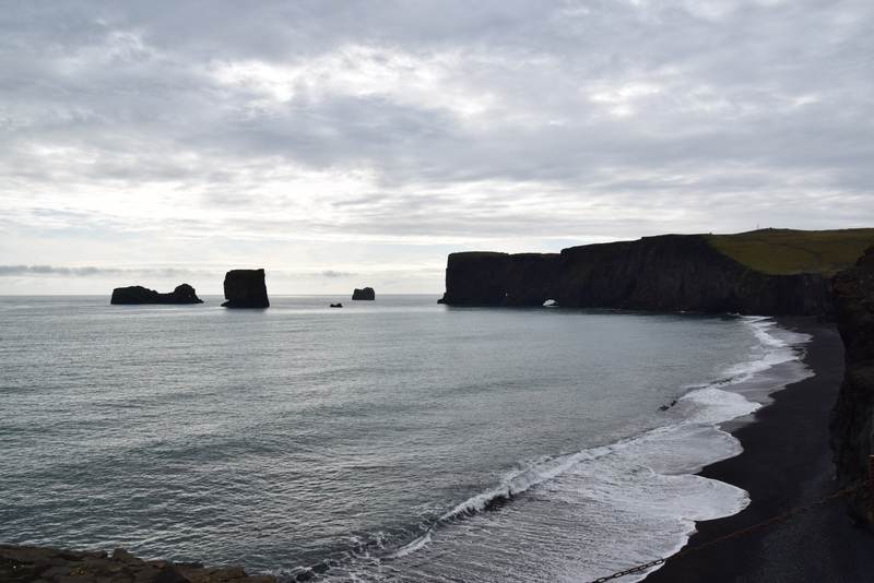
As the road got squeezed between the mountains and sea the local land form was rather reminiscent of Australia's Great Ocean Road.
Although not as extensive it has similar land forms with arches, pillars and smooth albeit black beaches.
However, this spot (Dyrholaey) will be remembered forever as it ticked off a long term bucket list item ….. PUFFINS – abounded in the turf atop these volcanic cliffs. Mind you humans were kept a good distance away so a zoom lens was essential.
Iceland has four major icecaps and our stop on day 4 was at Skaftafell which adjoins the largest (Vatnajokull) a spectacular sight as we approached.
By walking up a nearby rise we could see three glaciers. The one immediately behind the hotel was a bare 1 km walk. (I am guessing that the hotel has decided global warming and glacial retreat will continue as it backs onto the terminal moraine.) Here the glacier (which kept groaning and dripping) has clearly pushed up some material ahead of its migration down the valley.
Sometime ago in San Francisco we saw a man balancing rocks (see October 2014 blog). In Iceland (where there is plenty of material!) this has started to become a bit of a fad with many having a go – so not to be outdone….. Lets just say there is scope for being a little boulder.....
As we moved around the Icecap there were two glacier lagoons. The first was Breiðárlón which was much quieter than
the larger Jokulsarlon. The tide was coming in at quite a rate and pushing the icebergs back into the lagoon. All the eddies were being enjoyed by a dozen or so seals. There were also some icebergs that were clear blue and without the black ash coating that tarnished the majority.
As we reluctantly started to turn the SE corner and leave the icecaps and glaciers behind we were greeted by fiords. A whole different vista – some of which makes road construction quite a challenge. No shortage of tumbling boulders here…. We moved on quickly and looked forward to see what the North had to offer.

Thursday, August 16, 2018

The Yorkshire Coast

In order to recover from the walk and as the first non-walking day coincided with our 45th we decided to stay on the Yorkshire coast for a couple of days. The glorious weather continued and the warm and wet weather gear remained in the back pack.

The view from the Victoria pub over the gardens to the bay was glorious.
The main street in Robin Hoods Bay is steep with the buildings colourful and close together with alleyways similar to some Mediterranean towns. Our timing was great as the colour and atmosphere was suddenly enhanced by Morris dancers doing a jig down the street.
During the last three days of the walk we had seen the distant Whitby Abbey slowly increasing in size so we thought a closer look was warranted. Our arrival coincided with a play about Dracula with the players moving periodically through the Abbey with the audience in tow. All very amusing.
Helen had arranged for us to stay at Wrea Head hall, a country mansion just out of Scarborough. We had thought to play croquet but we were so busy doing nothing that we ran out of time……
The room was spectacular although the bed was quite high – not one to fall out of! The bath albeit in the bedroom also got a long work out.
Dinner in the 1881 restaurant was wonderful. I could not imagine a more mouth watering meal - a starter of Yorkshire pudding with beef strips and horseradish followed by Duck all washed down with a 10 year old bottle of Tempranillo.
The next day (after a particularly leisurely start) we visited Scarborough castle.
The view from the top over the town was commanding and the castle entry which incorporated a bridge with Barbican would have been a testing experience.
The grand hotel which dominates the sea front is now run by Butlins – not quite as grand as its heyday.
Once more our timing was great as a jousting tournament got underway shortly after our arrival. Getting the riders on their horses took quite a bit of time as they were very heavy in their chain mail and other regalia and had to use steps to access their mounts.
The jousting was skillful with rubber rather than steel “points”. The winner was the one that broke their lance as it meant they had had a solid hit.
This was followed by a melee where I think the winner was the one who struck the most blows on an opponent (either on the sword or shield). This was a pretty skillful exercise. Holding onto a twirling mount with one hand while hefting blows onto your opponents with a large sword was no mean feat. All were pretty exhausted by the end. An entertaining spectacle.

C2C East

Avid blog followers will know that in August 2016 we undertook the West side of the C2C across the Lake District. With sufficient elapsed time to forget the hard work involved we decided to start this years trip by undertaking the Eastern “half”.
Returning to Kirkby Stephen we stayed at a wonderful new B&B at Redmayne House. Having noticed an unusually strong country odour our hosts advised that just up the road were the evening sheep sales.

The yards have been around for many many years and it was obviously an activity with a small fraternity who seemed to enjoy the whole spectacle with some quite amusing moments. The lady to the left of the auctioneer was madly recording what was a quite frenetic process with sheep entering on one side just as others were leaving. She had the job of keeping an electronic record which is shown on a large screen above her head – the only sign of modern technology. 
A very serious business on some occasions – the top price has been 120,000 GBP for one ram…..
The next day we set off walking in glorious weather across a bridge over the river Eden.
As I did in 2016, the photos have been grouped into themes rather than a chronology. So for those keen to follow our route the schedule was:
Day 1 – 21 kms Kirkby Stephen to Keld
Day 2 - 17.5 kms Keld to Reeth
Day 3 – 17.5 kms Reeth to Richmond
Day 4 – 22.5 kms Richmond to Danby Wiske
Day 5 – 14.5 kms Danby Wiske to Ingleby Cross
Day 6 – 20 kms Ingleby Cross to Clay Bank Top
Day 7 – 15 kms Clay Bank Top to Blakey Ridge
Day 8 – 14.5 kms Blakey Ridge to Glaisdale
Day 9 – 13 kms Glaisdale to Littlebeck
Day 10 17.5 kms Littlebeck to Robin Hood’s Bay
Along the whole walk there were many animals of which sheep took prominence. As our knowledge of sheep varieties is limited Helen thought (given their legs) these could be aptly labelled Twiglets. (They are in fact Dalesbread.)
They are very comfortable with walkers being nearby.
Many of the paths were Bridleways.
There was also quite a bit of bird life of which pheasants were numerous
and Grouse were everywhere….
They do blend in well and
were fattening up for the start of the annual shoot – here Blakey and his mates would be able to shoot at will camouflaged in a line of Grouse Butts (This year the season started on the 13 August.)
We passed a Grouse farm which was fenced to prevent animals entering but with bespoke gates that allowed the birds to come and go at will. The fence did help with herding this deer so we could get a few (photo) shots.
However, the animal shot of the trip was this one on the last day. I noticed this animal initially walking towards me and then we both froze. As I clicked the shutter to get a great head on shot it lept 90 degrees and miraculously I got it in full flight. Any guesses? – it is a Weasel – the first I have seen in the wild.
Along the way there was some history – as this toll road was “unpersonned” it was particularly cheap.
And outright quirky – this farm had a few seats, a fridge with goodies and an honesty box so it was important to gain walkers attention as they went over the style.
The area is renowned for cycling and has its own Le Tour de Yorkshire as well as periodically being included in the Milk Race. As a result there are quite a few who pay homage with “sculptures” along the way.
Up the hill out of Littlebeck was “The Hermitage” which was carved out back in 1790 – a large sheltered space but its real purpose is unclear.
Of equally unclear purpose is the Nine Standards Rigg out of Kirkby Stephen which dates back to at least 1507. What is clear is that this is the highest point on our path East of the Lake District and lies on the watershed of Britain with rain on the left travelling to the Irish Sea and that on the right flowing to the North Sea.
We deviated off the course and across this pedestrian bridge so as to access Muker for a coffee. Elaborate double span only suitable for pedestrians.
Whereas this bridge near Glaisdale (the Beggars bridge) 
was specially tapered out at the top to enable horses with Panniers to pass without grazing the sides.
What was in abundance were “cowouses” (no “h”) which were used to winter cattle. Given the infrequency of cows I suspect they are no longer in much demand.
By comparison Richmond castle has adapted from fending off attackers to welcoming tourists. 
The river Swale was our guide for 4 or so days and in the flatter areas after Richmond was prone to flooding. To keep out of the fields the path migrated to the top of the flood wall. Quite a bit of concentration required given the 100+ metres length and 3 metre drop each side…..
Our arrival in Grosmount was heralded by a cuppa in the station tea rooms while we awaited the main attraction. We stopped here when we travelled by train with Michael et al last year (see York & Vikings July 2018)
This structure had me perplexed until Helen found a sign. It is near Robin Hoods Bay and is a rocket (rescue) pole. A line was shot by rocket to ships grounded in the bay and then a continuous line set up between the pole and a ships mast. A life belt with a pair of shorts (breeches buoy) was attached and the unfortunate crewmen were then hauled safely to shore. This one was used to rescue crew from the Heatherfield in January 1936.
Rights of way (the path) were generally well maintained although the purpose of this near new gate was a bit of a mystery. (At least everyone obeyed the sign and kept the gate closed.)
Some gardens along the way were worthy of note – the war memorial gardens in Richmond.
And our B&B near Clay Bank Top were highlights.
The scenery was diverse but gorgeous. From woodland walks near the river
To waterfalls
And waterfalls
And waterfalls
To some still water
And woodlands with wonderfully dappled light
However, the best views were at the top of the many climbs – this on the way down to Keld
And this the next day down to Muker
Clay Bank Top on the Yorkshire Moors has a great view of where we had trekked 
over three substantial escarpments – one of our bigger days.
Southwards the view was just a mass of heather.
And finally the view we had been looking forward to for much of the walk – the North Sea.
We met quite a few fellow trekkers and an American couple were good enough to take this shot so as to confirm I was there! One local walker tickled Helen's fancy when he "doffed" his cap at her.  The talking point for much of the day!
For several days we kept bumping into a German couple (Beate Lendt and Martin Klett who live in Holland). Being a little younger than us they usually started later in the day, caught us up at lunch time and were then waiting for us at the local pub for dinner. (Where were you - we have been worried sick??!!) It was quite eerie how this cycle kept repeating.
The last (very memorable) view was, as we rounded the headland, of Robin Hoods Bay. A welcome sight.
Thankfully the tide was in - low tide would have added a further 1 km to the trip! We promptly went to the waters edge and dipped our boots.
And tossed the long carried pebble from St Bees.
The Bay Hotel on the front
keeps a record of those who have completed the journey and provides a certificate (for a nominal fee!)
After a wonderful evening at the B&B we almost looked refreshed (or maybe that is relieved). (Zoom in on the tops.)
So there you have it – the C2C in 2 years! I suspect many of you will think we are nuts. However, although there is no doubt some of the walking was hard work the sense of achievement that we have walked across England will live with us forever. Along the way we have enjoyed some of the best countryside that England has to offer.
Thank you Wainright.....